Minqin Oasis

Groundwater Simulation of an Agricultural Region Suffering Desertification from Aquifer Overdraft with an AI Prediction Model
China is an ancient civilization with a storied history that dates back more than 5,000 years. Perhaps more than any civilization, China’s culture is water-centric, with words in their everyday language imbued with allusions to water. As eloquently conveyed in the “The Water Kingdom – A Secret History of China”:
“Water… is one of the most powerful vehicles for Chinese thought. At the same time, and for the same reasons, it has been one of the key determinants of Chinese civilization. It has governed the fate of emperors, shaped the contours of Chinese philosophy, and left its mark, quite literally, throughout the Chinese language. It is with water that heaven communicates its judgments to earth. Water pronounces on the right to govern.”
And yet because most of China is arid or semi-arid, this nation, home to more than one billion people with unprecedented potable, industrial and agricultural water demand, is severely water-stressed. Consequently, China as a single geographic entity is plagued by most if not all of the same water challenges as the rest of the world. Climate change induced drought, water quality degradation, groundwater overdraft, surface water depletion, environmental degradation, and water conflict, with the resulting water and associated food security problems are just some of the challenges they face.
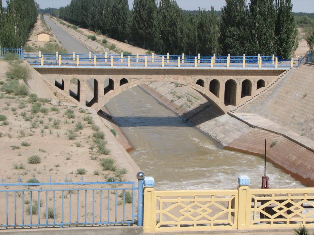
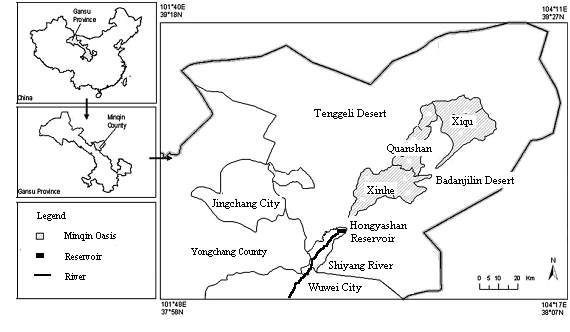
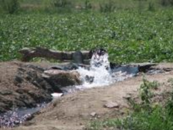
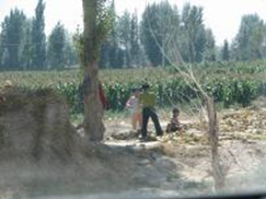
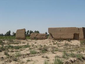
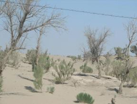
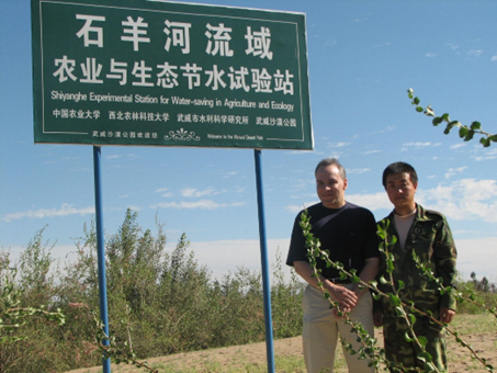
The Minqin Oasis located in northwest China is a cautionary tale of what awaits a region when its finite water supply is not sustainably managed. This was acknowledged by a former President of China, who on visiting the region decried its devastation as a “national tragedy.”
Formerly, a lush and fertile agricultural region that thrived in the midst of the Badanjilin and Tengeli deserts (Figure 1), it was truly an oasis in perfect equilibrium with land and water.
Figure 1. Map depicting the Minqin oasis, the lower reach of Shiyang River, and the Hongyashan reservoir (Courtesy of: Huo Zailin, Ph.D. and Professor Shaoyuan Feng, College of Water Conservancy and Civil Engineering, China Agricultural University).
The region once had an abundant water supply consisting of a vast shallow water table aquifer, lakes, and a large river to supply its water needs.
The most obvious water source is the Shiyang River, which after flowing into the Hongyashan Reservoir (Photo 1), is then conveyed into the Minqin Oasis (Photo 2).
Photo1: The Shiyang River, the largest desert river in Asia, meets the Hongyashan Reservoir, constructed in 1956. Courtesy of Dr. Coppola
Photo 2: An irrigation canal conveying precious surface water from the Hongyashan reservoir to oasis farmland. Courtesy of Dr. Coppola
Photo 3: Sunflower Crops in the Oasis. Courtesy of Dr. Coppola
The oasis, ancestral homeland for thousands of farmers, rely on increasingly scarce water resources to support a variety of crops, from cotton to sunflower. (Photos 3 and 4).
Photo 4: Cotton Crops in the Oasis. Courtesy of Dr. Coppola
Because of increasingly higher water extractions from the Shiyang River, combined with excessive groundwater pumping within the region (Photo 5), the water table has declined significantly over the last several decades, violating the once dynamic equilibrium between desert and oasis.
Photo 5: An oasis irrigation well exploiting the increasingly scarce groundwater resource. Courtesy of Dr. Coppola
As a June, 2006 New York Times front page article reported: “An ever-rising tide of sand has claimed grasslands, ponds, lakes and forests, swallowed whole villages and forced tens of thousands of people to flee as it surges south and threatens to render this ancient Silk Road greenbelt uninhabitable” (Photos 6, 7, and 8).
Photo 6: Young children playing in the fields with visible desert sand encroachment. Courtesy of Dr. Coppola
Photo 7: A long abandoned dwelling located within the “Lake District” of the oasis, with sunflowers growing in the background. Courtesy of Dr. Coppola
Photo 8: Once fertile agricultural fields have been reduced to desert wasteland, now the single largest source of dust storms in Asia. Courtesy of Dr. Coppola
The severe consequences of this regional desertification extend far beyond the greenbelt, as the Minqin Oasis has become the single largest source of dust storms in Asia, even impacting the City of Beijing, located far away on the western coast of China. Forced to drill deeper wells, the older groundwater has high concentrations of arsenic and other dangerous heavy metals, causing cancer rates of residents and livestock to soar in the region.
NOAH was asked by the China Agricultural University, College of Water Conservancy and Civil Engineering, to visit the Minqin Oasis and assess their use of AI for accurately modeling monthly groundwater elevations in the region in response to variable climate, hydrologic, and agricultural conditions.
Figure 2 depicts AI predicted versus observed groundwater levels for the region. Not only did the AI model achieve highly accurate simulations, it also revealed the dynamic inter-relationships between groundwater elevations in the oasis and numerous factors, including surface water levels in the Hongyashan reservoir, agricultural extractions, and climate conditions.
Figure 2. Comparison of observed versus ANN predicted groundwater levels during validation for the Minqin Oasis. (Courtesy of: Dr. Huo Zailin, and Professor Shaoyuan Feng, College of Water Conservancy and Civil Engineering, China Agricultural University).
The Chinese researchers used the AI models to simulate future groundwater levels under a variety of possible climate and agricultural conditions, as depicted by Figure 3.
Figure 3. ANN groundwater level simulation results for the Minqin oasis using monthly stress periods projected over a one-year horizon using different irrigation areas in the Minqin Oasis. (Courtesy of: Dr. Huo Zailin and Professor Shaoyuan Feng, College of Water Conservancy and Civil Engineering, China Agricultural University).
The AI models serve as a prediction and decision-making tool for water allocations within the region based upon existing and projected conditions.
Dr. Coppola was invited to a remote desert research center in the region (Photo 9) where Chinese researchers are investigating ways to maximize agricultural production with the most efficient water use possible.
Photo 9. Dr. Coppola with Researcher at the Shiyanghe Experimental Station in Wuwei Desert Park. Courtesy of Dr. Coppola
The research center utilizes multiple remote water stations (Photo 10) to accurately measure site-specific variables like air temperature, humidity, and evaporation.
Photo 10. Remote Weather Station. Courtesy of Dr. Coppola
The researchers instrument individual plants (Photo 11) and fruits (Photo 12) to measure their individual water consumption.
Photo 11. Measuring a tree’s water consumption. Courtesy of Dr. Coppola
Related to the above, the researchers investigate the effects of agricultural practices like mulch applications to increase food production while reducing water consumption (Photo 13).
Photo 12. Measuring a fruit’s water consumption. Courtesy of Dr. Coppola
Photo 13. Researching the effects of different mulch on maize production and water conservation. Courtesy of Dr. Coppola
The research and modeling results demonstrate the critical connection between system characterization via data collection, which supports development of accurate AI prediction and simulation models for even highly complex regional systems. As droughts and other extreme events like floods intensified by climate change become more prevalent and destructive across the globe, advanced data collection and AI data processing and prediction methods will become indispensable for effectively managing and protecting our limited water resources.