New Jersey
A Streamflow Based Drought Index Forecasting System with AI Prediction Models
Droughts are becoming more frequent and persistent, challenging water managers to meet the growing demand of increasingly thirsty populations, thereby forcing a rethinking of developing and implementing more effective techniques and strategies for forecasting and managing drought. The Intergovernmental Panel on Climate Change warns that because of climate change, “droughts will especially increase in subtropical areas, such as the U.S. Southwest, Australia and parts of Africa and Europe, as Earth’s warming causes more evaporation and shifts weather patterns, pushing the paths of storms that bring thirst-quenching rains farther north.”
One of the calamitous impacts of drought are reduced river flows and lake levels, which often have disastrous effects on agriculture, energy production, and society as a whole. Major rivers around the world have been severely diminished by climate change, made worse by their over-use for water supply. These include the Colorado River in the United States, Rhine River in Germany, Nile River in Egypt, Yellow River in China, and Murray River in Australia. Similarly, groundwater supplies can be severely impacted by drought due to reduced groundwater recharge rates associated with lower precipitation and higher evaporation.
The objective of this project was to assess the feasibility of implementing an AI-based drought forecasting system to predict streamflow conditions in response to variable weather and hydrological conditions, thereby providing decision makers with effective lead time to anticipate and mitigate drought related impacts.
Drought status is commonly determined by drought indices, which are general measures of the hydrological, meteorological, and/or agricultural state of the system. Typical drought indices include groundwater levels, surface water flows, deviation of precipitation from its historical mean precipitation, soil moisture deficits, and available supplies in surface water reservoirs. As implied by the indices, there is a wide range of drought conditions, which necessitate different status designations and correspondingly, different mitigative response measures. In addition, the drought status as measured by various indices can vary significantly over space within a decision-making boundary.
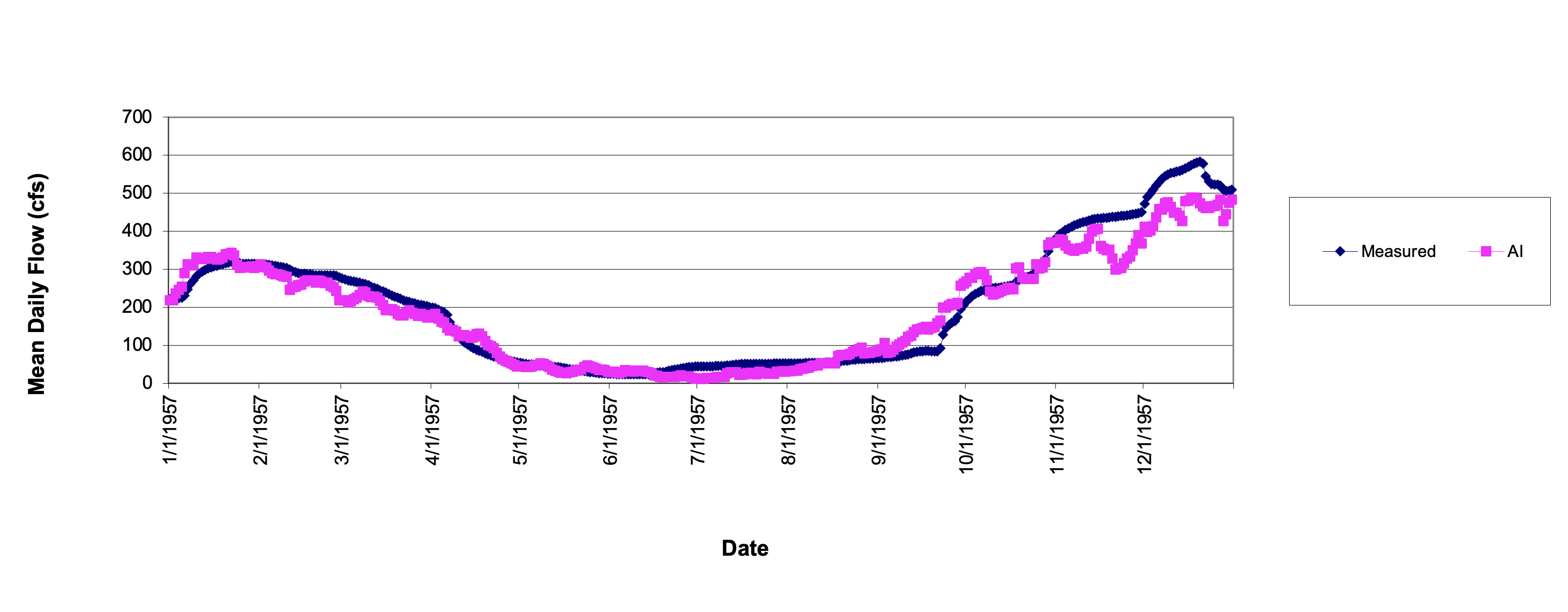
Figure 1. AI Extended Drought Simulation for Year 1957
The New Jersey Geological Survey (NJGS) is responsible for monitoring and assessing drought conditions across the State of New Jersey, using, in part, an ambient streamflow monitoring network within the context of historical hydrologic data. The streamflow drought monitoring network consists of eighteen gauged streamflow locations in six drought regions across the state. The Ramapo near Mahwah stream gauge, located on the Ramapo River downstream of the New York-New Jersey border, was selected primarily for this study because of its long historical record of data.
AI models were developed to predict average daily streamflow rates over 30-, 60-, and 90-day ahead periods using hydrologic and weather conditions as well as forecasted (in this case, measured future) weather conditions. A variety of weather and hydrologic related variables were used as inputs to the AI models, which were identified during AI testing and sensitivity analyses. Despite being trained with streamflow data that generally exceeded that of drought conditions, the AI model still accurately reproduced higher and lower streamflow rates during over extended drought periods, achieving an average correlation coefficient of 0.91.
To further demonstrate ANN capability for accurately simulating extended multi-year drought periods, select drought years were excluded from the data used to develop a single ANN model. The ANN model was then used to simulate streamflow rates during the excluded drought years to assess its ability to reproduce extreme conditions over prolonged periods. The excluded drought years were: 1957, 1963-1965, 1995, and 1998. Note that four drought years were included in the development data set (1961-1962, 1966, and 1999) so that the ANN model would be exposed to extreme drought conditions during training.
Figures 1 through 4 depict the extended streamflow simulations generated by the AI models for extended drought periods, and how their predictions compared to the actual measured flow rates.
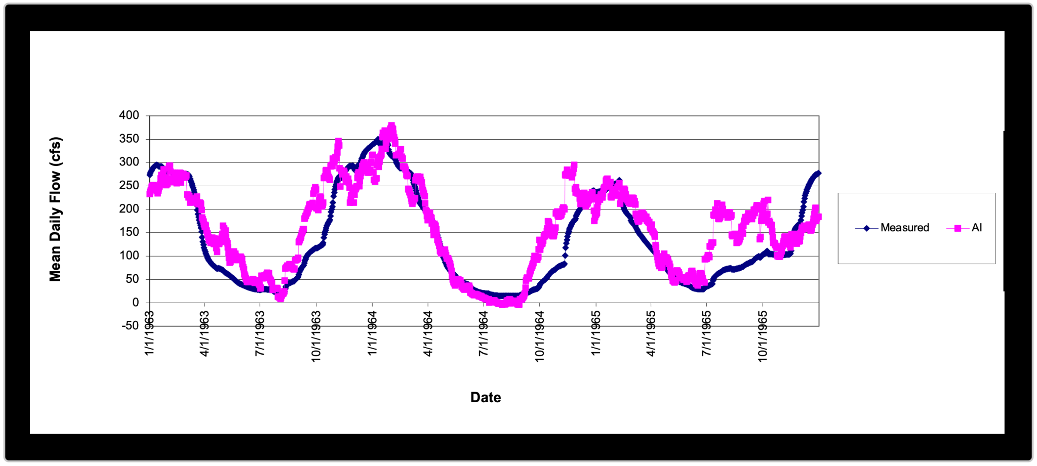
Figure 2. AI Extended Drought Simulation for Years 1963 through 1965
The AI models generally accurately predicted and simulated streamflow rates over extended multi-year periods during normal and extreme drought conditions.

Figure 3. AI Extended Drought Simulation for Year 1995

Figure 4. AI Extended Drought Simulation for Year 1998
All too frequently, “drought only receives the attention of decision makers when it is at peak levels of intensity and spatial extent and when water management options are quite limited. This approach is sometimes referred to as the “hydro-illogical cycle” where concern and panic lead to a reactive response to associated economic, social and environmental impacts, followed by apathy when precipitation restarts and water resources return to normal.
A pro-active drought forecasting system serves as both an early alert warning system for drought and as the foundation for a real-time optimization management tool for water resources, providing water managers and decision makers with numerous benefits during drought and other conditions. To account for weather uncertainty, probabilistic ANN forecasts generate confidence intervals for forecasted streamflow conditions over the time periods of interest. Conversely, this AI-based streamflow forecasting can also be deployed as an early warning flood forecasting system.